THE SOCIALIST REPUBLIC OF VIET NAM
Government News
Storm Molave heads for sea water between Da Nang and Phu Yen
VGP – Storm Molave, the nine of this kind to hit Viet Nam this year, is moving west-northwest with speed of 20-25 kph and projected to hit the sea area between Da Nang and Phu Yen in the next 24 hours, according to the National Center for Hydro-Meteorological Forecasting.
|
|
|
Storm Molave‘s expected path
|
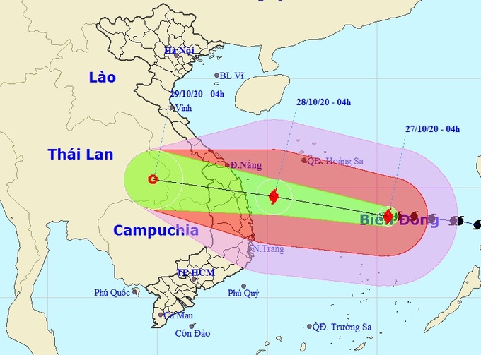
Around 4:00 a.m. on Tuesday, the storm lay centered around 320 km north-eastnorth of Southwest Cay with winds of 135-150 kph.
Over the next 24 hours it will move west-northwest at 20-25 kph and gradually intensify. At around 4 a.m. on Tuesday it will reach the area of sea between Da Nang and Phu Yen in which wind speed will increase to 165 kph.
In the next 24 to 48 hours, the storm will move west-westnorth at around 25 kph and make landfall between Da Nang and Phu Yen, before weakening into a tropical depression.
At 4:00 a.m on Thursday, Molave will reach the East of Thailand with a maximum wind speed of 40 kph.
The Gulf of Tonkin and area of sea between Quang Tri and Thua Thien Hue (including Tiger Island) will be affected by storm circulation and cold weather with strong sea levels from 4-6 meters. The area of sea between Khanh Hoa and Binh Thuan will witness high sea levels of 3-5 meters.
From October 28-31, area between Nghe An and Quang Tri will see extremely heavy rainfall with an average rate of 200-400 mm. Especially, the southern area of Nghe An and Ha Tinh will experience 500-700 mm of rainfall at the fourth natural disaster risk level.
Earlier, about 130 had been killed by floods and landslides triggered by heavy rains between October 6 and 25 in the central region./.
By Kim Anh