Dak Nong Geopark recognized as Global Geopark
VGP – Dak Nong Geopark in the Central Highlands province of Dak Nong has been recognized as the Global Geopark at the 209th UNESCO Executive Board on July 7.
 |
|
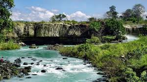
Dak Nong Geopark |
Located on the M’Nong plateau at average elevation of 600-700m asl, with the highest point being Ta Dung at 1,982m asl, Dak Nong Geopark - the Land of Sounds - covers an area of c.4,760km2.
According to the UNESCO, Dak Nong Geopark is distinctive in terms of geological features and geoheritage value. Being a piece of the Gondwana ancient supercontinent, from about 200-165 Ma ago it was deeply submerged into a passive continent marginal sea, very rich in ammonite and bivalve fossils. This continental margin later, during 145-66 Ma ago became active due to plate collision, with red-bed sediments, eruptive andesite-dacite-
During the last 16.5 Ma, the territory became active again with wide-spread, multi-phase volcanic activities, forming a basalt cover over more than 50% of the Geopark area. These have been the source of some of the world’s largest and top quality bauxite deposits and a number of other minerals (sapphire, semi-precious stones etc.), and especially the fertile soils that have fed generations of local people with many industrial and fruit tree crops.
In particular, young volcanic activities about tens of thousands of years ago (Late Pleistocene-Holocene) have resulted in spectacular craters, majestic waterfalls and Southeast Asia’s most extensive system of hundreds of magnificent volcanic caves, many of which had been used by prehistoric people as shelter since at least 6,000-10,000 years ago.
The Viet Nam National Commission for UNESCO and Dak Nong Province’s People’s Committee and other relevant agencies, domestic and foreign scientist will launch plans on protecting environment, preserving natural resources, maintaining and upholding values on geology, biodiversity, culture, history and ethnic traditions in the area.
By Thuy Dung